Official Name:
ЛЦбТЙиЖўЕРБпГЄГЧ2ЖЮHuangYaGuanErDaoBianChangCheng2DuanOur Name:
/
Other Name:
/
Period:Уї / Ming Dynasty 1368~1644
Location: ЬьНђЪа,ЬьНђЪа,МЛЯи,ЯТгЊеђЛЦбТЙиДхЖЋББ1.1ЧЇУз / TianJinShi,TianJinShi,JiXian,XiaYingZhenHuangYaGuanCunDongBei11QianMi
ЁЁ[
Looking Local List]
Details:ГЄГЧРрБ№ЃКЧНЬх
Ц№ЕуОЮГИпЖШЃКЖЋОЃК117Ёу 26Ёф ББЮГЃК40Ёу 15Ёф КЃАЮЃК469
жеЕуОЮГИпЖШЃКЖЋОЃК117Ёу 26Ёф ББЮГЃК40Ёу 15Ёф КЃАЮЃК371
ЧНЬхзпЯђЃКДЫЖЮЧНЬхздЛЦбТЙиГЄГЧЖўЕРБп1ЖЮЩНЯежЙЕуЃЌЫГЩНЪЦЃЌжСЛЦбТЙиГЄГЧ3ЖЮЩНЯеЦ№ЕуЃЌзпЯђЮЊЖЋФЯжСЮїББзпЯђЁЃ
ЧНЬхРрБ№ЃКЪЏЧН
НсЙЙЬиЕуМАЙЙжўЗНЪНЃКИУЖЮГЄГЧВЩгУЪЏПщИЩРнЖјГЩЁЃ
РнЦіЗНЗЈЃК
ДгВПЗжЧНЬхЖЯУцЙлВьЃЌЧНЬхЕФРнЦіЗНЗЈгывдЭљЕФЧНЬхЛљБОЯрЭЌЃЌвВЪЧЧНЬхЕФФкЭтСНВрОљВЩгУНЯДѓЕФЪЏПщРнЦіГЩСНЕРЭтЧНБпЃЌШЛКѓдкетСНЕРЧНЬхжаМфгУЯрЖдаЁЕФЪЏПщКЭЫщЪЏЦЌЁЂЭСЬюГфЃЌаЮГЩЭъећЕФЧНЬхЁЃЧНЬхгаЪеЗжЁЃ
ЯжзДЃКДЫЖЮГЄГЧЮЊЪЏЧНЁЃДЫЖЮЖўЕРБпГЄГЧЧНЬхећЬхБЃДцНЯВюЃЌЮЛгкЛЦбТЙиЖЋВПЕФЩНМЙЩЯЃЌШЋГЄ230УзЃЌАДЬиеїЕуПЩЗжЮЊ2аЁЖЮРДУшЪіЃК
1ЁЂЦ№ЕузјБъЃК117Ёу26Ёф28.44ЁхEЃЌ40Ёу15Ёф03.78ЁхNЃЌКЃАЮ469УзЃЌжЙЕузјБъЃК117Ёу26Ёф27.06ЁхEЃЌ40Ёу15Ёф05.76ЁхNЃЌКЃАЮ430УзЁЃ
ДЫаЁЖЮЧНЬхБЃДцНЯВюЃЌГЄ70УзЃЌФкЭтЧНОљвбЬЎЫњЃЌЪЏПщЬЎЫњгкФкЭтВрЃЌВПЗжЧНЬхРнЦігкЩНЬхбвЪЏЩЯЃЌФмЗжБцЕФЧНЬхЃКПэ3.60УзЃЌЭтЧНИп3.05УзЃЌФкЧНИп20РхУзЃЌЩдгаЪеЗжЁЃжЙЕуЯђЮїББЯТелЁЃ
2ЁЂжЙЕузјБъЃК117Ёу26Ёф27.06ЁхEЃЌ40Ёу15Ёф05.76ЁхNЃЌКЃАЮ430УзЃЌжЙЕузјБъЃК117Ёу26Ёф20.34ЁхEЃЌ40Ёу15Ёф05.34ЁхNЃЌКЃАЮ371УзЁЃ
ДЫаЁЖЮЧНЬхБЃДцНЯВюЃЌГЄ160УзЃЌЧНЬхЩЯЕФАќзЉБЛШЫЮЊВ№Г§ЦЦЛЕЁЃ
Type:ЪЏЧН Stone wall
Protection Level:ЪЁБЃ
ЁЁ
Content:
Memo:
Other Records:
Distribution:
visit location in Tianditu Map[recommend] Distribution:
visit location in Tencent QQ Map Distribution:
visit location in Google MapDistribution:
visit location in Baidu MapNational ID:120225382102170154
Action:[
 Save in Data Basket
 ]
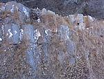
Picture:
Click the thumbnail to view the Big Pic. Click the Big Pic to Hide the Big Pic![Caption:ЛЦбТЙиЖўЕРБпГЄГЧ2ЖЮ
loading images --Please wait...]() Photo Links
Photo Links:
ЁЁ Search ::
  Favorite/My Favorite :: Recent Changes :: :: Login