Official Name:
半仙屯长城BanXianTunChangChengOur Name:
/
Other Name:
/
Period:明 / Ming Dynasty 1368~1644
Location: 锦州市,黑山县,起点:八道壕镇八道壕村半仙屯(西700米)止点:八道壕镇八道壕村半仙屯(西北1250米)石家沟长城1号敌台 / JinZhouShi,HeiShanXian,QiDianBaDaoHaoZhenBaDaoHaoCunBanXianTun(Xi700Mi)ZhiDianBaDaoHaoZhenBaDaoHaoCunBanXianTun(XiBei1250Mi)ShiJiaGouChangCheng1HaoDiTai
[
Looking Local List]
Details:长城类别:墙体
起点经纬高度:东经:121° 56′ 北纬:41° 49′ 海拔:116
终点经纬高度:东经:121° 56′ 北纬:41° 49′ 海拔:136
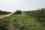
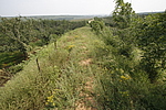
墙体走向:墙体大体呈东南-西北走向。该段长城起自八道壕镇八道壕村半仙屯(西700米),长城从东南向西北呈上行走势,止于八道壕镇八道壕村半仙屯(西1250米处)、石家沟长城1号敌台。
墙体类别:土墙
结构特点及构筑方式:剖面呈梯形。该段长城墙体为自然沉积沙石基础,墙体设施无存。主墙底宽6米,上宽1米,残高1米。副墙长537米,底宽8米,上宽1.5米,残高1米~1.5米。
现状:土墙。
Type:土墙 Rammed earth wall
Protection Level:无
Content:
Memo:
Other Records:
Distribution:
visit location in Tianditu Map[recommend] Distribution:
visit location in Tencent QQ Map Distribution:
visit location in Google MapDistribution:
visit location in Baidu MapNational ID:210726382101170022
Action:[
 Save in Data Basket
 ]
Picture:
Click the thumbnail to view the Big Pic. Click the Big Pic to Hide the Big Pic![Caption:半仙屯长城
loading images --Please wait...]()
![Caption:半仙屯长城
loading images --Please wait...]() Photo Links
Photo Links:
 Search ::
  Favorite/My Favorite :: Recent Changes :: :: Login