Official Name:
团山沟长城(复线)TuanShanGouChangChengFuXianOur Name:
/
Other Name:
/
Period:明 / Ming Dynasty 1368~1644
Location: 锦州市,北镇市,起点:大市镇大一村大砬子山底团山沟屯(东北1000米)止点:大市镇大一村大团山沟屯(东南1300米) / JinZhouShi,BeiZhenShi,QiDianDaShiZhenDaYiCunDaZiShanDiTuanShanGouTun(DongBei1000Mi)ZhiDianDaShiZhenDaYiCunDaTuanShanGouTun(DongNan1300Mi)
[
Looking Local List]
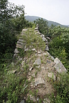
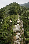
Details:长城类别:墙体
起点经纬高度:东经:121° 44′ 北纬:41° 47′ 海拔:181
终点经纬高度:东经:121° 44′ 北纬:41° 46′ 海拔:420
墙体走向:墙体大体呈东北-西南转东南转西南走向。该段长城石墙起自大市镇大一村大砬子山底团山沟屯(东北1000米),一路自东北向西南由丘陵向山上呈上行走势,止于大市镇大一村团山沟屯(东南1300米处)。
墙体类别:石墙
结构特点及构筑方式:剖面呈梯形。该段主墙体基础为自然山体岩石基础,墙身用石块砌筑,内填碎石土而成,墙体向上收分不明显,剖面为梯形,墙体设施无存。墙宽0.4米~1.6米,现存高度0.4米~2米。
现状:该墙体为石墙,石质以硅岩为主,质地坚硬。
Type:石墙 Stone wall
Protection Level:无
Content:
Memo:
Other Records:
Distribution:
visit location in Tianditu Map[recommend] Distribution:
visit location in Tencent QQ Map Distribution:
visit location in Google MapDistribution:
visit location in Baidu MapNational ID:210782382102170003
Action:[
 Save in Data Basket
 ]
Picture:
Click the thumbnail to view the Big Pic. Click the Big Pic to Hide the Big Pic![Caption:团山沟长城(复线)
loading images --Please wait...]()
![Caption:团山沟长城(复线)
loading images --Please wait...]() Photo Links
Photo Links:
 Search ::
  Favorite/My Favorite :: Recent Changes :: :: Login