Official Name:
永兴村1段土墙YongXingCun1DuanTuQiangOur Name:
城西南墙 / ChengXiNanQiang
Other Name:
/
Period:明 / Ming Dynasty 1368~1644
Location: 宁夏回族自治区,中卫市,中宁县,余丁乡永兴村一队西北约2.2千米--余丁乡永兴村一队西北约2.4千米 / NingXiaHuiZuZiZhiQu,ZhongWeiShi,ZhongNingXian,YuDingXiangYongXingCunYiDuiXiBeiYue22QianMiYuDingXiangYongXingCunYiDuiXiBeiYue24QianMi
[
Looking Local List]
Details:长城类别:墙体
起点经纬高度:东经:105° 28′ 北纬:37° 30′ 海拔:1206
终点经纬高度:东经:105° 28′ 北纬:37° 30′ 海拔:1207
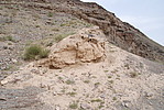
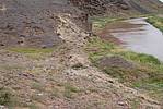
墙体走向:此段土墙位于两道陡峭的山体间,是从东侧山体半坡处(GPSA0431点)开始,随山坡而下,过沟底,再沿西侧山坡而上,最后至西侧山坡的陡坡处(GPSA0434点)截止,全长170.4米。此段墙体随山体坡面分布,地势呈两侧高、中间低的U字形,落差较大;方向较直,呈东北-西南向。
墙体类别:土墙
结构特点及构筑方式:无。
采集标本概括性介绍:
无。此段墙体是在原生沙石地表上找平、以黄土分段夯筑而成,土质疏松、细密,含水量少,包含有少量青灰色小石粒。
现状:土墙。
Type:土墙 Rammed earth wall
Protection Level:省保
Content:
Memo:
Other Records:
Distribution:
visit location in Tianditu Map[recommend] Distribution:
visit location in Tencent QQ Map Distribution:
visit location in Google MapDistribution:
visit location in Baidu MapNational ID:640521382101170174
Action:[
 Save in Data Basket
 ]
Picture:
Click the thumbnail to view the Big Pic. Click the Big Pic to Hide the Big Pic![Caption:永兴村1段土墙
loading images --Please wait...]()
![Caption:永兴村1段土墙
loading images --Please wait...]() Photo Links
Photo Links:
 Search ::
  Favorite/My Favorite :: Recent Changes :: :: Login