Official Name:
施家坪村战国秦长城ShiJiaPingCunZhanGuoQinChangChengOur Name:
/
Other Name:
/
Period:战国秦 / Warring States 475~221 B.C.
Location: 宁夏回族自治区,固原市,彭阳县,孟塬乡赵山庄柳家堡子东北沟畔(GPS0163点)――孟塬乡虎山庄三岔口敌台(GPS0164点) / NingXiaHuiZuZiZhiQu,GuYuanShi,PengYangXian,MengXiangZhaoShanZhuangLiuJiaBaoZiDongBeiGouPan(GPS0163Dian)MengXiangHuShanZhuangSanChaKouDiTai(GPS0164Dian)
[
Looking Local List]
Details:长城类别:墙体
起点经纬高度:东经:106° 51′ 北纬:35° 54′ 海拔:1664
终点经纬高度:东经:106° 49′ 北纬:35° 52′ 海拔:1475
墙体走向:
墙体类别:土墙
结构特点及构筑方式:无。不清。
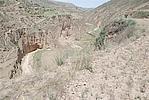
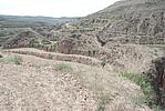
现状:此段墙体从刘家堡子沟畔处开始沿山坡向沟底延伸,经草庙乡施家坪村,止于三岔沟敌台处,地势北高南低,落差较大。大部地段沟壑纵横,为陡峭的荒草坡,沟底有小溪水,沿线未发现墙体痕迹,墙体可能崩毁入沟谷内,整体属消失段落。其间分布有1座敌台。按其特征及保存现状分为1段:
GPS0163--GPS0164点,长4002米。消失。
损坏情况及原因:
此段墙体已消失,其损毁原因主要为自然因素。
自然因素主要有:
山洪雨水冲断,此段土墙所处区域水土流失严重,沟壑纵横,沟底及山坡段有多处雨水冲刷断壕。
人为因素主要有:
居民修建梯田、栽植防风林带,对墙体造成不同程度的破坏。
Type:土墙 Rammed earth wall
Protection Level:国保
Content:
Memo:
Other Records:
Distribution:
visit location in Tianditu Map[recommend] Distribution:
visit location in Tencent QQ Map Distribution:
visit location in Google MapDistribution:
visit location in Baidu MapNational ID:640425382101020007
Action:[
 Save in Data Basket
 ]
Picture:
Click the thumbnail to view the Big Pic. Click the Big Pic to Hide the Big Pic![Caption:施家坪村战国秦长城
loading images --Please wait...]()
![Caption:施家坪村战国秦长城
loading images --Please wait...]() Photo Links
Photo Links:
 Search ::
  Favorite/My Favorite :: Recent Changes :: :: Login