Official Name:
海子峡口城障HaiZiXiaKouChengZhangOur Name:
/
Other Name:
/
Period:战国秦、秦汉 / Han Dynasty 206 B.C.~316A.D.
Location: 宁夏回族自治区,固原市,原州区,中河乡吴庄村海子峡口 / NingXiaHuiZuZiZhiQu,GuYuanShi,YuanZhouQu,ZhongHeXiangWuZhuangCunHaiZiXiaKou
[
Looking Local List]
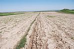
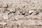
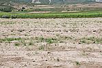
Details:长城类别:关堡
经纬高度:东经:106° 10′ 北纬:35° 58′ 海拔:1887
总体情况:
附近遗存:西墙田埂上有大量绳纹瓦残片。采集有日用陶器残片、汉“半两”铜钱,一字型铁锸、绳纹瓦片、卷云纹瓦当等物。地质、地形地貌:
中河乡位于原州区城区西部、中水河上游,西与西吉县相邻,北与彭堡镇相接,东与清河镇毗邻,南与张易镇相连。土地面积149平方公里。中河乡西南为六盘山山地,东北为中河、大营河谷地,地势西南高、东北低。
Type:堡 Fort
Protection Level:国保
Content:
Memo:
Other Records:
Distribution:
visit location in Tianditu Map[recommend] Distribution:
visit location in Tencent QQ Map Distribution:
visit location in Google MapDistribution:
visit location in Baidu MapNational ID:640402353102040013
Action:[
 Save in Data Basket
 ]
Picture:
Click the thumbnail to view the Big Pic. Click the Big Pic to Hide the Big Pic![Caption:海子峡口城障
loading images --Please wait...]()
![Caption:海子峡口城障
loading images --Please wait...]()
![Caption:海子峡口城障
loading images --Please wait...]() Photo Links
Photo Links:
 Search ::
  Favorite/My Favorite :: Recent Changes :: :: Login