Official Name:
头塘长城2段TouTangChangCheng2DuanOur Name:
浩门河 / HaoMenHe
Other Name:
/
Period:明 / Ming Dynasty 1368~1644
Location: 青海省,海北藏族自治州,门源回族自治县,起点:浩门镇头塘村村西0.1千米的夹道沟口止点:浩门镇南关村西南2千米的浩门河北岸 / QingHaiSheng,HaiBeiCangZuZiZhiZhou,MenYuanHuiZuZiZhiXian,QiDianHaoMenZhenTouTangCunCunXi01QianMiDeJiaDaoGouKouZhiDianHaoMenZhenNanGuanCunXiNan2QianMiDeHaoMenHeBeiAn
[
Looking Local List]
Details:长城类别:墙体
起点经纬高度:东经:101° 36′ 北纬:37° 21′ 海拔:2851
终点经纬高度:东经:101° 36′ 北纬:37° 21′ 海拔:2837
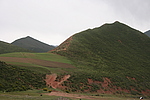
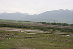
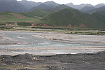
墙体走向:头塘长城2段南起自浩门镇头塘村村西100米的夹道沟口GPS0009,过浩门河到北岸浩门镇南关村西南2千米的门源县三进硅铁有限公司厂区南墙外浩门河北岸岸边GPS0010止,整体呈西南至东北走向。
墙体类别:河险
结构特点及构筑方式:此段长城河险以天然形成的波涛汹涌的浩门河及河道作为天然屏障,利用自然地理环境达到军事防御的目的。
现状:此段长城河险以波涛汹涌的浩门河作为天然屏障,达到阻挡骑兵的军事防御目的,属河险。
Type:河险 Precipitous river
Protection Level:无
Content:
Memo:
Other Records:
Distribution:
visit location in Tianditu Map[recommend] Distribution:
visit location in Tencent QQ Map Distribution:
visit location in Google MapDistribution:
visit location in Baidu MapNational ID:632221382107170003
Action:[
 Save in Data Basket
 ]
Picture:
Click the thumbnail to view the Big Pic. Click the Big Pic to Hide the Big Pic![Caption:头塘长城2段
loading images --Please wait...]()
![Caption:头塘长城2段
loading images --Please wait...]()
![Caption:头塘长城2段
loading images --Please wait...]() Photo Links
Photo Links:
 Search ::
  Favorite/My Favorite :: Recent Changes :: :: Login