| [ Login ]/[ Register ] |
 Search ::
  My Data Basket ::
  Favorite/My Favorite :: Recent Changes :: :: Login Save in Data Basket ]
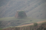
| Caption:走马墕烽火台 Photo Time:2008-06-19 17:54:47 Photo Contributor:山西省文物局 [Open in New Window] |
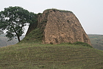
| Caption:走马墕烽火台 Photo Time:2008-06-19 18:02:49 Photo Contributor:山西省文物局 [Open in New Window] |
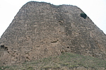
| Caption:走马墕烽火台 Photo Time:2008-06-19 18:05:45 Photo Contributor:山西省文物局 [Open in New Window] |
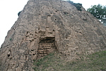
| Caption:走马墕烽火台 Photo Time:2008-06-19 18:06:06 Photo Contributor:山西省文物局 [Open in New Window] |