Official Name:
猪儿洼村东侧敌台ZhuErWaCunDongCeDiTaiOur Name:
“台墩” / TaiDun
Other Name:
/
Period:秦汉 / Han Dynasty 206 B.C.~316A.D.
Location: 山西省,大同市,左云县,山西省左云县张家场乡猪儿洼村村村内东侧 / ShanXiSheng,DaTongShi,ZuoYunXian,ShanXiShengZuoYunXianZhangJiaChangXiangZhuErWaCunCunCunNeiDongCe
[
Looking Local List]
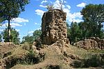
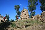
Details:长城类别:单体建筑
经纬高度:东经:112° 50′ 北纬:40° 06′ 海拔:1265
建筑形式:
材料:黄土夯筑而成,土质较硬、较纯,土中夹杂有碎石,夯层厚0.19米-0.27米。
附近遗存:猪儿洼村东侧敌台是猪儿洼村北侧长城起点。
Type:敌台 Defence Tower
Protection Level:省保
Content:
Memo:
Other Records:
Distribution:
visit location in Tianditu Map[recommend] Distribution:
visit location in Tencent QQ Map Distribution:
visit location in Google MapDistribution:
visit location in Baidu MapNational ID:140226352101040001
Action:[
 Save in Data Basket
 ]
Picture:
Click the thumbnail to view the Big Pic. Click the Big Pic to Hide the Big Pic![Caption:猪儿洼村东侧敌台
loading images --Please wait...]()
![Caption:猪儿洼村东侧敌台
loading images --Please wait...]()
![Caption:猪儿洼村东侧敌台
loading images --Please wait...]() Photo Links
Photo Links:
 Search ::
  Favorite/My Favorite :: Recent Changes :: :: Login