Official Name:
∂Ģ ģ»żīŚ4ļŇĶ–Ő®ErShiSanCun4HaoDiTaiOur Name:
∂’Ő® / DunTai
Other Name:
/
Period:√ų / Ming Dynasty 1368~1644
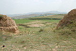
Location: ńŕ√…ĻŇ◊‘÷ő«Ý,ļŰļÕļ∆Őō –,ļÕŃ÷łŮ∂ŻŌō,ńŕ√…ĻŇļŰļÕļ∆Őō –ļÕŃ÷łŮ∂ŻŌō–¬ĶÍ◊”ŌÁ«į≤ňńĺĪīīŚ∂ę‘ľ1«ß√◊ / NeiMengGuZiZhiQu,HuHeHaoTeShi,HeLinGeErXian,NeiMengGuHuHeHaoTeShiHeLinGeErXianXinDianZiXiangQianCaiMuBeiCunDongYue1QianMi
°°[
Looking Local List]
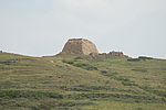
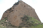
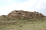
Details:≥§≥«ņŗĪū£ļĶ•ŐŚĹ®÷Ģ
ĺ≠ő≥łŖ∂»£ļ∂ęĺ≠£ļ112°„ 17°š ĪĪő≥£ļ40°„ 13°š ļ£įő£ļ1355
Ĺ®÷Ģ–ő Ĺ£ļŅ’–ńĶ–Ő®£¨ő™»ňĻ§Ľ∆ÕŃļĽ÷Ģ£¨∆Ĺ√ś≥ ’ż∑Ĺ–ő£¨∆ √śő™Ő›–ő°
≤ńŃŌ£ļĶ–Ő®”–Ľ∆ÕŃļĽ÷Ģ∂Ý≥…£¨ļĽ≤„ńŕőř»őļőŐŪľ”őÔ°£
łĹĹŁ“Ňīś£ļ∆š∂ęĪĪ∑Ĺ≤Ľ‘∂ī¶ő™∂Ģ ģ»żīŚ∑ťĽūŐ®°£
Type:Ķ–Ő® Defence Tower
Protection Level:őř
°°
Content:
Memo:
Other Records:
Distribution:
visit location in Tianditu Map[recommend] Distribution:
visit location in Tencent QQ Map Distribution:
visit location in Google MapDistribution:
visit location in Baidu MapNational ID:150123352101170004
The original number submitted by the local government £ļ150123352101170123
(when the Great Wall is identified, the data whose code has been adjusted will display the original number submitted by the local government before revision, which can be used by the local cultural relics department when checking the local data.)
Action:[
 Save in Data Basket
 ]
Picture:
Click the thumbnail to view the Big Pic. Click the Big Pic to Hide the Big Pic![Caption:∂Ģ ģ»żīŚ4ļŇĶ–Ő®
loading images --Please wait...]()
![Caption:∂Ģ ģ»żīŚ4ļŇĶ–Ő®
loading images --Please wait...]()
![Caption:∂Ģ ģ»żīŚ4ļŇĶ–Ő®
loading images --Please wait...]()
![Caption:∂Ģ ģ»żīŚ4ļŇĶ–Ő®
loading images --Please wait...]() Photo Links
Photo Links:
°° Search ::
  Favorite/My Favorite :: Recent Changes :: :: Login