Official Name:
茅岭底长城1段MaoLingDiChangCheng1DuanOur Name:
/
Other Name:
/
Period:明 / Ming Dynasty 1368~1644
Location: 河北省,邯郸市,涉县,茅岭底村西南1.0千米处 / HeBeiSheng,HanDanShi,SheXian,MaoLingDiCunXiNan10QianMiChu
[
Looking Local List]
Details:长城类别:墙体
起点经纬高度:东经:113° 30′ 北纬:36° 42′ 海拔:607
终点经纬高度:东经:113° 30′ 北纬:36° 42′ 海拔:641
墙体走向:西南-东北。
墙体类别:石墙
结构特点及构筑方式:此段墙体为毛石干垒,内用山皮土填芯。
不同时期叠圧关系:无
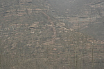
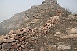
现状:墙体位于茅岭底村西南约1千米,清漳河分支--漳西渠北岸的山坡上,全长64米,起点坐标
墙体由“茅岭底长城1段起点”至“茅岭底长城1段止点”为南北走向,总体保存较差。顶部残宽1.2-1.6米,底部残宽1.5-2.6米,内侧残高1.8-2米,外侧残高1-1.8米。为大块岩石垒砌而成,部分地段利用自然山石作为基础,砌墙所用的石块由下至上逐渐变小,至顶部改为小块片石垒砌。此段墙体呈阶梯状,分为三阶,每阶高差为1.7米-2.4米。
墙体南侧为一条小河,南侧临近河边处有一座石砌券门残址。向为则为山险。此处河谷宽约250米。
Type:石墙 Stone wall
Protection Level:省保
Content:
Memo:
Other Records:
Distribution:
visit location in Tianditu Map[recommend] Distribution:
visit location in Tencent QQ Map Distribution:
visit location in Google MapDistribution:
visit location in Baidu MapNational ID:130426382102170004
Action:[
 Save in Data Basket
 ]
Picture:
Click the thumbnail to view the Big Pic. Click the Big Pic to Hide the Big Pic![Caption:茅岭底长城1段
loading images --Please wait...]()
![Caption:茅岭底长城1段
loading images --Please wait...]() Photo Links
Photo Links:
 Search ::
  Favorite/My Favorite :: Recent Changes :: :: Login